Following the launch this summer of Eircodes, the Republic of Ireland’s new postal addressing system, an enhanced Eircode dataset has been released by the allmapdata team at Mapmechanics, including map co-ordinates for all addresses plus free boundary data for principal post towns.
Mapmechanics is a specialist in UK and worldwide mapping, business and demographic data, business intelligence (BI) and geographic information systems.
Until this year, the Republic of Ireland had no postcode system comparable to the one in the UK. Up to 600,000 Irish street addresses (more than a third of all addresses) were duplicated. This made it difficult to automate delivery scheduling and to use address data in computer-based business planning and analysis or geographic information systems (GIS).
Postal data codes not compulsory
The new Eircode system, developed by the Irish Government, has tackled this problem by allocating individual codes to all 2.2 million Irish addresses. Their use is not compulsory, but the expectation is that they will be adopted quickly throughout the business community.
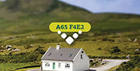
UK postcodes mostly apply to groups of properties, but each seven-character alphanumeric Eircode is unique to a single property. In blocks of flats, even an individual flat has its own code. This makes the codes particularly accurate for delivery management, and for very precise business analysis and planning.
The allmapdata Eircodes dataset includes location information in both Irish National Grid reference and latitude and longitude. Addresses are included in both English and Irish and the data identifies its DED (district electoral division), together with other details for each property.
The data also enables users to link addresses with other Irish datasets held at different levels of geography.
The first three characters of each Eircode make up a ‘routing key’, containing details of the post town applying to the address, while the final four digits represent a ‘unique identifier’ for each property. A typical code looks thus: A65 F4E2.
However, Eircodes do not include any equivalent to the sector, district and area information incorporated in UK postcodes, which positions groups of addresses within the their broader geographical context. To make the new codes more effective in thematic mapping and analysis (for instance, for shading the areas covered by groups of codes), the allmapdata team has created boundaries for each of the three-digit routing keys. These created boundaries represent 139 principal post towns. This makes it possible to shade the mapping thematically at principal town level. These polygons have been included in the dataset, free.
Details of the Eircodes from allmapdata dataset are available: allmapdata.